 |
| Meteorological imagery Detection of low clouds in infrared Meteosat images based on a contextual spatio-temporal labeling approach |
Contact: P. Bouthemy
| Demo overview |
We present a method of detection of low clouds (fog, stratus...) from infrared Meteosat images. The infrared channel providing a temperature map of the scene, is the only usable one by night for the study of low clouds. The use of one static image is generally not sufficient to distinguish between low clouds and ground, which may display similar temperature. To alleviate this problem, we introduce the use of local spatial context and the profit of motion-based information derived from a pair of images. The proposed method is based on a Markovian modeling of the dynamic, thermal and spatial properties of the elements constituting the scene. We consider a labeling process in two classes ("clear sky" and "low clouds") of presegmented areas of interest. We have designed an unsupervised scheme to estimate the thermal parameters of the data-driven term. The minimization of the energy function is performed in an iterative way using a deterministic relaxation technique (ICM). Information is propagated from regions of reliable local motion measurements towards less contrasted regions of the image. |
| Main features of the method |
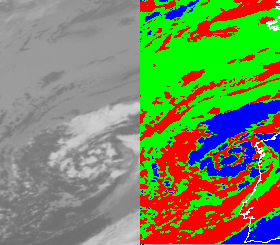
| Sequences of segmentation maps |
|
 |
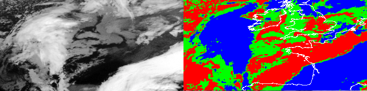 |
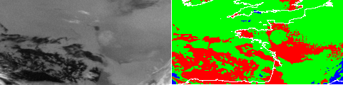
| Comparison of results with "ground truth" |
 |  |
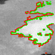 | 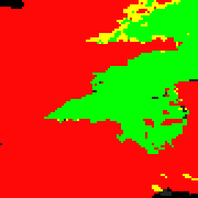 |
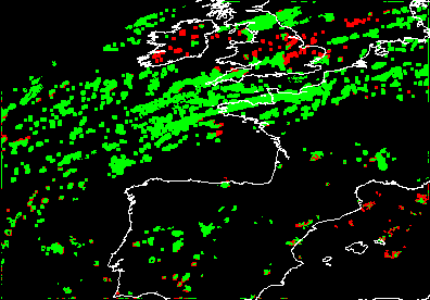
Proposed classification: clear sky, low clouds, other clouds.
"Ground truth" classification: land, low clouds, sea, cloud border, other clouds.
We compare our segmentation maps with those resulting from a method based on a static pixel-based analysis of multispectral NOAA images. This method, developed by the Center of Spatial Meteorology in Lannion, exploits the difference between the near infrared and the thermal infrared channels to directly detect low clouds. Moreover the spatial resolution of these images is higher, but the temporal interval of image capture is larger. Thus, we have access to only one NOAA image by night. The significant contribution of the near infrared channel enables to consider the cloud classification maps obtained from NOAA images as relevant ground truth. The comparison process must nevertheless take into account that the projection used in NOAA maps and Meteosat maps are different.
| Algorithm implementation |
| |
 | The spatio-temporal intensity gradients allow us to measure local information related to the observed motion between two successive images. Stratus and fog are characterized by a rather smooth and featureness appearance which does not facilitate this intensity gradient-based motion evaluation. Therefore, it is important to qualify the reliability of this motion-based information at each pixel according to the spatial intensity gradient distribution in the vicinity of this pixel. |
| |
 | The thermal parameters of the data-driven term of the energy function to be minimized are estimated for each class. In order to remove spatial ambiguities in temperature (distinct temperatures associated to a given class, similar temperatures characterizing two different classes), we estimate these parameters (mean and variance) within each block resulting from a partition of the image. For each block, relevant histograms of temperature associated to each class are determined and modeled by mixtures of Gaussian laws. |
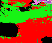
| ||
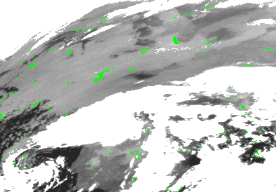 |  | Using local motion-based and thermal criteria, we select pixels (in green on the left image) stated as the most reliably labeled as low cloud. We propagate this initial labeling towards regions rather uniform and providing uncertain motion-based measurements. Relaxation involving the regularisation energy term starts from these first labeled sites and their neighbourhood, and is progressively extended. This iterative relaxation scheme is stopped when the entire image has been treated (right image). |
| Applications |
| The goal of this study is to provide forecasters with an additional source of numerical information on low clouds. An accurate and early localization of ow clouds which are formed during the night, is of primary importance in order to ensure safety of the road and air traffic . |
| Collaborations |
| References |
|
Webmaster : vista_webmaster@irisa.fr Last modified: Thu Aug 31 15:05:50 MET DST 2000 |
|
|